Ulyanovsk Region - a subject in the central part of Russia with an area of 37 thousand km2... It is located in three climatic zones at once: southern taiga, forest-steppe with areas of pine and mixed forests, and steppe. The region is part of the Volga regions, the great river divides it into the right bank (Volga Upland) and the steppe left bank. The region is called the land of springs due to its many springs.
The nature of the Ulyanovsk region has more than 160 specially protected natural zones. All of them are called upon to protect the species diversity of the flora and fauna of our country. Among the landscapes of the region you can find hills, low mountains, marshy plains, steppes and meadows. On the territory of all natural monuments, economic activities, construction and felling are prohibited. There are special rules of conduct for tourists.
The most interesting natural monuments in the region
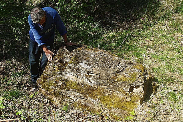
Baevsky petrified tree
Not far from the village of Baevo, Kuzovatovsky district, there is a unique paleobotanical monument: several fragments of a fossilized cypress trunk with a root system preserved in the ground. It was discovered back in 1886. At the moment, the estimated age of the tree is 250 years. It is located in the middle of a pine forest in the Naleykin forestry, and it will not be easy to find it. However, a walk through these places, rich in rare plants, will bring a lot of pleasure.

Vinnovskaya Grove
The natural park is located in Ulyanovsk, on the banks of the Volga. A piece of the ancient relict forest was able to survive during the construction of Simbirsk and is carefully guarded today. The linden-oak grove has about 280 species of vegetation. Previously, it was located on the territory of the village of Vinnovka, from where it got its name. There is a memorial pavilion of I.A.Goncharov in the park. The writer describes these places in the novel "The Break". Next to the old forest there is a city recreation park of the same name.

Yulovsky pond
The reservoir was formed on the Black River by artificial means about 100 years ago. However, thanks to its favorable location and clean running water, the dam acquired the character of a lake. Here aquatic and coastal vegetation is widely represented, typical for natural reservoirs, waterfowl are found. The length of the lake is 2 km, its width is up to 500 meters, and the depth reaches 10-15 meters. In the vicinity there are pine forests, berry bushes, clean springs.

Language park
A landscape monument of the 19th century has been preserved in the village of Yazykovo, Korsunsky district. The park was laid out around the Yazykovs' manor. The manor building itself was destroyed. However, the general outline of the park, alleys, ponds, 100-year-old trees and even a 200-year-old spruce, which is called "Pushkinskaya" (the writer visited the estate in 1833), have been preserved. Today it is a good place for walking with a unique atmosphere of the century before last.

White lake
Located in the center of the Volga Upland, the age of the reservoir is estimated at 250 thousand years. The lake is oval, 1 km wide, 1.6 km long. The depth is on average 3-4 meters. It is named so because of the very clean water (the lake is able to clean itself on its own) and the white sand at the bottom. Due to the high altitude of 320 meters, northern plants, uncharacteristic for this area, grow here, the air is very clean and is considered healing. On the shore of the lake there is a sanatorium, a recreation center and a camping.

Lake Peschanoe
Near the village of Chardakly there is a unique group of 5 lakes. They are interconnected by an underground lake, which is why ebbs and flows occur here. The largest lake is Peschanoe, in the shape of the "eight". Length 1.3 km, width - up to 570 meters. Its area reached 40 hectares, there were a lot of fish, rare birds nested along the banks, weasel and mink were found. Now Sandy becomes shallow and polluted because of the plant built on the shore.

Spring Timai
The spring has been known for a very long time, as it is located on an old path. Travelers have always stayed here for rest. Now the road from the village of Staroye Timoshkino to Barysh is little used, but local residents take water from the spring. It was landscaped, enclosed in a wooden pavilion. The water is soft, always cold, and drinkable in all its characteristics.

Akshuat Dedropark
The natural monument is located in the Barysh region near the village of Akshuat. Founded with the aim of stopping the spread of sandy soils, the park has a century-old history of cultivating and researching rare and exotic plants. Currently, more than 70 species of exotic species grow here. Hiking trails have been laid through the park, routes have been launched. There is a sports camp.

Skripinsky Kuchury
A natural monument, represented by a ridge of rocky hills, is located in the Terengulsky district of the Ulyanovsk region. The hills are covered with pine forests, formed from sandstone rocks that came to the surface. It is believed that the entire Volga Upland had such a landscape before the onset of the Ice Age. The territory of the natural zone is more than 200 hectares. Many mysterious legends are associated with this place. Here you can breathe in the healing air and enjoy the amazing landscapes.

The source of the Syzranka river
In the Barysh district, not far from the village of Karmaleyka, the Syzranka river originates. The terrain is swampy, at the top of the lowland there is a clean cold spring - it gives rise to the river. A thin stream flows out of the spring. The source has been landscaped, a wooden blockhouse has been built around it. In the bogs, there are rare species of aquatic vegetation that add value to the natural monument.

The source of the Sura river
The second largest right tributary of the Volga originates in the Ulyanovsk region, near the village of Surskie Vershiny. In the past, the river originated from two streams. Now in this place, after deforestation and construction of dams, the springs are heavily silted up. The place of the source is now marked 2 km from the former, where in the forest, among thickets of willow, bird cherry and fern, a fast winding river begins. Small springs and streams feed on its banks. In the upper reaches of the Sura, it is very clean and transparent.

Zimin mountain
The second name of the natural monument is the Surulovskaya forest-steppe. Occupies an area of 334 hectares on the border of the Radishchevsky and Novospassky districts. The main part of the tract is occupied by a hill, its maximum elevation is 335 meters above sea level. The summits are formed by chalk deposits of sandy and stony-sandy rocks. Ancient forests with rare plants, insects and animals are of great scientific interest.

Forested upper reaches of the Sengileika River
As a special natural zone, 300 hectares have been allocated in the Sengileevsky forestry. A forest area with a wide variety of trees and shrubs, herbaceous plants is under protection. Sengileika is a small river, 17 km long. In the upper reaches, the water is cool and fairly clean, due to which river trout is found here. The water resources of the river, as well as the adjacent territory, are also protected.

Landslide circus
It is located in the vicinity of the village of Shilovka, in the Sengileevsky forest. The territory of the protected natural zone is 22 hectares. It is a ravine cut into the northeastern slope of the Kriushinsky cape. Earlier, the Volga arm flowed at its foot. On the slopes of the ravine, numerous landslides and ravines have formed a characteristic stepped relief. The object is of great scientific interest for the study of landslide processes, minerals and rocks.

Remnant Grannoe Ear
It is located 3 km north of the city of Sengiley. It is a mountain covered with dense forest with a height of 333.7 meters above sea level. This is one of the highest points of the Volga Upland. The top of the mountain is treeless, offering beautiful views of the Volga and its surroundings.In the past, rock was mined on the slopes, after which 10-meter steep cliffs remained. Legends about the campaigns of Stepan Razin are associated with this place.

Borok Island
The official name of the island is Karsnoyarskiy. It is located in the Kuibyshev reservoir, Cheremshansky Bay, near the village of Nikolskoye-on-Cheremshan. The island is home to the second largest colony of gray herons on the Volga, more than 400 pairs. There are other types of birds, including rare species listed in the Red Book. In order to preserve and increase the population of rare species, the entire ecosystem of the island is under protection.

Swamp Kochkar
The swamp got its name due to the large number of hummocks protruding above the surface. Located on the outskirts of the Cherdakly village, it covers an area of about 40 hectares. Formed after the shallowing of a large lake, in the middle there are areas with open water. More than 30 species of aquatic and semi-aquatic birds live here, including those rare for this region. In order to preserve species diversity and population, the bog itself, the meadow and its surroundings are under protection.

Spring Dubrovka
The spring is named after the village in which it is located. Bet from the ground at the mouth of the ravine, has a large and powerful discharge of water. Water comes out through one main funnel and several secondary ones. Both the water and the bottom of the stream are very clean. There are several comfortable approaches to the water. In this area, sports competitions are often held among fans of extreme sports.

Spring Window
It is located in the Inzensky district, not far from the village of Yashenka. It is a monument not only of nature, but also of history, as it was a source of water for military training camps during the Second World War, at the same time a wooden trap was built, which has survived to this day. The area of the security zone is 1.5 hectares. The spring waters feed the Yashinka stream, which flows into Yulovka.

Paltsinsky Island
It is located near Ulyanovsk, on the Kuibyshev reservoir. It is separated from the left bank by 3 km of water surface, and from the right - 6. It is a narrow strip of land 1.5 km long and up to 300 meters wide. The floristic diversity of the island is of interest, especially the 100-year-old pine trees. The nesting sites of rare and endangered birds have been marked. The island has strict rules for organizing recreation.

Oreshnik tract
It is a section of a watershed near the village of Enganaevo, Cherdaklinsky District, which was previously a forest zone. After deforestation, woody vegetation recovered only partially, the main part of the area was occupied by forest-steppe. A large number of melliferous plants grow on the territory, which has a beneficial effect on the population of wild bees and wasps. In general, the ecosystem is of scientific value and is a good food base for beneficial insects.

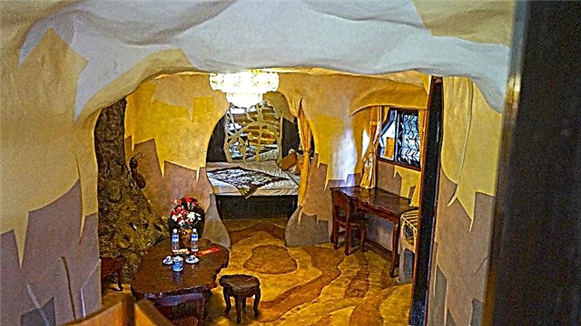
Red Walk Caves
The complex of caves is located on Zmeinaya Gorka, at a distance of 3 km from the village of Krasny Gulyai, in the Sengileevsky district. The chain consists of several grottoes, small caves and one large cave of three halls with a total length of more than 80 m. This is the only complex of caves in the Ulyanovsk region. Their origin is karst. The largest cave covers an area of over 300 m2... Several species of bats are found inside.

Milanovsky section
The section of rocks got its name from the name of the scientist who was engaged in the study of geological faults. Located on the northern outskirts of Ulyanovsk. It is a section of the Volga bank 180 meters long and 30 meters high. The landslide slowly engulfs part of the city's territory, which threatens development. The sediment section is of great interest for paleontology and lithology.

Zotovo lake
The total area of the natural monument exceeds 1000 hectares, the lake itself occupies 36 hectares. It is located in the Kuzovatovsky region, in the Volga right bank, in the forest-steppe zone. The protected natural area was established with the aim of maintaining a unique forest and lake ecosystem. The lake is named after the forestry dynasty. A wide variety of both woody and meadow crops grows here.

Eagle coast
The reserve was established in the 80s of the XX century with the aim of protecting endangered bird species. There are nesting sites for white-tailed eagles included in the Red Book of Russia. In our country, there are only a few dozen pairs of such birds. The territory of the reserve is about 84 hectares, here rare birds, animals and plants are under special control. You can visit the reserve both independently and with an excursion: at any time of the year you can enjoy the beautiful landscapes and learn interesting features from the life of the inhabitants.